PHOTO GALLERY
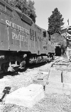
The mountain line had
automatic block signaling between Vasona Junction and Santa Cruz. Though
the signals are long gone several of the concrete signal bases are still
in place along the line. On October 25, 1984, SP GP9E 3838 parks next to
one such base at the south end of Mission Hill tunnel in Santa Cruz. (Jon
Pullman Porter)
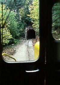
Approaching Tunnel 5
from the cab of Big Trees CF7 2641. This bore has since been daylighted
by SCBT&P.
(Ken Rattenne)
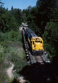
On March 20, 1988 Santa
Cruz Big Trees & Pacific CF7 2641 leads a Central Coast excursion near
Olympia. This may have been the first passenger train through Olympia since
No. 34 with the last train from Los Gatos in 1940. (Ken Rattenne)
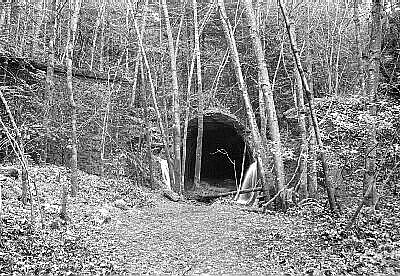
Deep in the Santa Cruz
Mountains on February 7, 1984, the summit tunnel at Wrights shows the effects
of 44 years of nature's reclamation efforts. (Jon Pullman Porter)
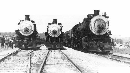
Three
Suntan Specials wait out the day at the Santa Cruz Yard during the late
1930s. In only a matter of a couple of years these trains will lose their
mountain crossing. click the photo to enlarge. (Rattenne Collection)
|
After
a devastating winter storm in 1940, SP abandoned their line over the Santa
Cruz Mountains.
June 4, 2000 marked the 60th
anniversary of the abandonment of Southern Pacific's line over the Santa
Cruz Mountains between Los Gatos, a small community in the foothills south
of San Jose, and Olympia, 8.8 miles north of Santa Cruz. Officially, the
line was the Los Altos-Santa Cruz Branch on the San Francisco Subdivision
of the Coast Division.
The
route had been completed in May of 1880 by the South Pacific Coast Railroad
as part of its narrow-gauge line between Alameda and Santa Cruz. SPC was
taken over by SP in 1887 and the line was standard-gauged around 1907.
By the late 1930s the line was down to one through freight a day in each
direction. Passenger service, though by now loosing $30,000 a year, was
still provided between San Francisco and Santa Cruz by trains 31, 32, 33,
34 and 47.
On
the afternoon of February 26, 1940 the line was closed by mud slides and
wash-outs following several days of turbulent storms. Train #34, the 11:26
a.m. arrival from San Francisco, likely had the dubious distinction of
being the last train to run over the "hill," ending 60 years of operations.
Train #33, the evening train to San Francisco, ran via Watsonville Junction
that night. Regular Santa Cruz passenger service ended after that.
SP
initially planned to reopen the line, and even had the route listed in
the March 30, 1940 timetable. However, facing an estimated $55,000 in repairs,
coupled with competition from newly-opened Highway 17, SP threw in the
towel and filed for abandonment of the 16?mile section between Los Gatos
and Olympia.
SP initially planned to reopen the line,
and even had the route listed in the March 30, 1940 timetable.
Once
permission was granted on June 4, the rails were pulled up, with much of
the right-of-way being taken over by the water district. Lexington Dam
was built in 1952, displacing the former town sites of Alma and Lyndon
with a two-mile-long reservoir. Highway 17 was rerouted around downtown
Los Gatos in 1956, severing the route SP had taken from the station down
into Los Gatos Canyon. In 1958 the line was further cut back with the abandonment
of the 2.5 mile section between downtown Los Gatos and Vasona Junction.
In
1982 SP halted service between Eblis siding in north Santa Cruz and Olympia,
but left the 7.7 miles of track in place. Even so, when tourist operator
Santa Cruz, Big Trees and Pacific took over the line just three years later
they encountered fallen trees across the tracks, sections buried by mud
slides, shifts in track alignment (the line crosses the San Andreas Fault
between Wright's and Laurel), erosion of the right-of-way that left track
and ties dangling in the air, and pools of water from clogged drainage
pipes. Basically the same maintenance headaches railroaders have faced
since the mountain line opened a century earlier.
Despite
all this, 60 years later parts of the abandoned line remain remarkably
intact. Tunnel portals, crossties, trestle supports, signal bases and other
relics are visible along the overgrown right-of-way. The route along Los
Gatos Creek is now part of a hiking and bike path as far as the reservoir.
Trestle supports near Lyndon and Aldercroft are still in place, but today
carry large water pipes instead of rails. The towering concrete bridge
piers at Wright's (or Wright, as it was listed in SP timetables in later
years), stand abandoned amid dense forest growth but still display, in
faded paint, their admonition not to stand too close as "
rocks etc. might
fall from passing trains."
Much of the mystique of the mountain line involves the tunnels
on the route -- nearly three miles of bores were required over the 24-mile
distance between Los Gatos and Santa Cruz. The longest tunnels, the 6,157
foot summit tunnel at Wright's and the 5,793 foot tunnel between Laurel
and Glenwood, have especially become part of the legend and lore that has
always surrounded the Santa Cruz Mountains.
60 years later parts of the abandoned line remain
remarkably intact.
Though the line passed into history in 1940, its ghost
offers the enticing prospect of relieving traffic congestion on Highway
17, while haunting Santa Cruz residents with the fear of their town being
overrun by tourists and commuters. Embraced by transportation planners
in Santa Clara County and held at arm's length by their counterparts in
Santa Cruz, studies and proposals to re-open the line have appeared on
a regular basis for the past 30 years.
A
1971 study by Lockheed determined that 37 percent of the original route
was still in use, 27 percent could be easily restored and 36 percent would
require new construction, principally around Lexington Reservoir and Los
Gatos. The cost was estimated at $50 million.
Most proposals have advocated the use of light-rail electric
trains. One of the latest plans proposed an $8.20 toll on Highway 17 to
fund the estimated $500 to $600 million it would cost to reopen the line
as a transit corridor. Santa Cruz officials vetoed revival proposals in
1977, 1982 and 1991 and have indicated a reluctance to participate in new
studies.
One
proposal that seems to be gaining momentum is the restoration of passenger
service via Watsonville Junction, the route the Suntan Special used after
the mountain line was severed. The Suntan covered the 70 miles between
San Jose and Santa Cruz in two hours, just 24 minutes longer than trains
took over the mountain line. Transit times would be close to the old running
time over the mountain if the Watsonville-Santa Cruz line could be upgraded
to allow 35-40 mph speeds. This route is attractive since Monterey is clamoring
for passenger service, and could possibly pool equipment with a San Jose-Watsonville
Junction-Santa Cruz operation.
|
|
Sources:
-
A Centennial South Pacific Coast by Bruce MacGregor
and Richard Truesdale, published by Pruett Publishing Company, Boulder,
Col. 1982.
-
Narrow Gauge Portrait South Pacific Coast, by Bruce
MacGregor, published by Glenwood Publishing, Felton, Cal., 1975.
-
California Central Coast Railways by Rick Hamman,
published by Pruett Publishing Company, Boulder, Col., 1980.
-
Highway 17 The Road to Santa Cruz by Richard A. Beal,
published by The Pacific Group, Aptos, Cal., 1991.
-
San Francisco Chronicle, April 9, 1993
-
Santa Cruz Sentinel, October 29, 1971
|